


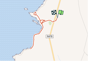
Centre visiteurs Falaises de Moher - 3 km

jeanmarcMasson
User GUIDE

Length
3.3 km

Max alt
169 m

Uphill gradient
283 m
Km-Effort
7.1 km

Min alt
5 m

Downhill gradient
283 m
Boucle
Yes
Creation date :
2024-05-28 16:07:52.797
Updated on :
2024-05-28 16:10:20.377
1h36
Difficulty : Medium

FREE GPS app for hiking
 SityTrail
IGN / Geographical institutes
SityTrail Plus
The world is yours!
About
Trail Walking of 3.3 km to be discovered at Unknown, County Clare, West Clare Municipal District. This trail is proposed by jeanmarcMasson.
Positioning
Country:
Ireland
Region :
Unknown
Department/Province :
County Clare
Municipality :
West Clare Municipal District
Location:
Ballysteen
Start:(Dec)
Start:(UTM)
471608 ; 5869270 (29U) N.
Comments